Home & Garden
48 Hours of Arctic Misery Ahead
"Warm-Mittens-and-Brandy Advisory" issued: Bone-chilling cold descends on us Sunday morning.


Tonight ushers in another burst of super-cold arctic air, with a low of 7 degrees and wind chill values as low as 7 below, which will run through the next two days. Sunday brings us a high near 10 degrees and wind chills of 13 below zero, according to the National Weather Service forecast.
These will be the coldest temperatures of the winter so far. Remember last winter? The fabled Chiberia winter? The next few days will be reminiscent of that bitter chill we had to swallow.
Find out what's happening in Lislefor free with the latest updates from Patch.
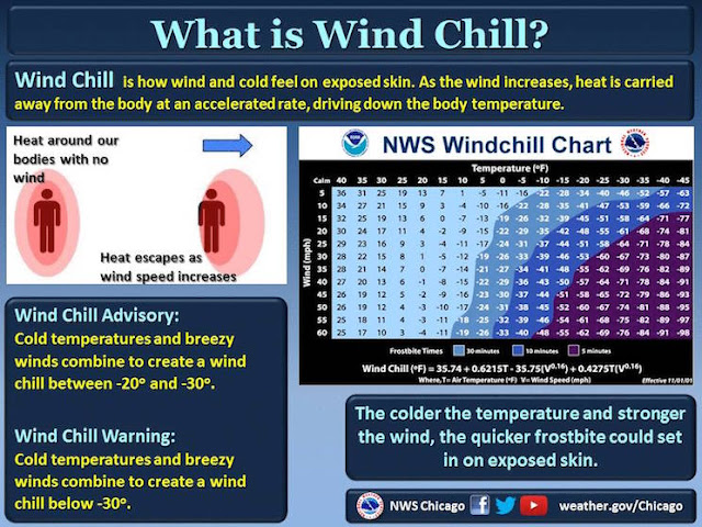
Definitely mitten-and-scarf weather. And big furry or knit hats, too. A wind-chill advisory is in effect through Sunday for northeast Illinois.
Ice jams on local rivers are possible due to the frigid temperatures, the NWS warns.
Find out what's happening in Lislefor free with the latest updates from Patch.
And the super-cold continues Monday, with 22-below-zero wind chills and gusts of wind at 20 miles per hour.
We also have a slight chance of snow Tuesday evening, starting at 5 a.m., with increasing chance of snow through Wednesday evening.


Really! You Should Wear Your Gloves
Get more local news delivered straight to your inbox. Sign up for free Patch newsletters and alerts.